Gookin & How 1696 Land Survey
The following descriptions are transcribed as legible.

List of persons who purchased land from Samuel Gookin and Samuel How
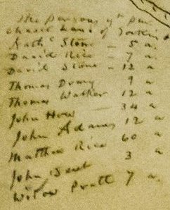
The persons that purchased land of Gookin and How
Nathaniel Stone 5 a
David Rice 7 a
David Stone 12 a
Thomas Drury 9 a
Thomas Walker 12 a
John How 34 a
John Adams 12 a
Matthew Rice 60 a
John Bent 3 a
Widow Pratt 7 a
Title
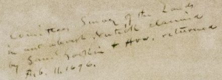
Committees Survey of the Lands in and about Natick, claimed by Samuel Gookin and How, returned Feb. 11, 1696.
Notes from the Court Hearing
To the Honorable General Court now sitting - We whose names are under written, by order of this Court bearing date December 13, 1695, being ordered to survey the Land in Natick Township claimed by Mr. Samuel Gookin of Cambridge & Samuel How of Sudbury: we have accordingly measured said land, & we find of the Land which said Gookin & How have sold and disposed of To several persons, 1700 acres full measure, which by information that we have had, the said Gookin & How have sold to the value of 156 pounds, which we account the full value of said land. We have also measured the land betwixt the aforesaid land and Sherborn line, which we have been informed has been claimed by said Gookin and How, and not disposed of, which we find to measure 1000 acres, which we value to be worth 60 pounds of which we have herein drawn a plot of the lines thereof.
We have also set out to the said Gookin and How 200 acres, according to the General Courts order, adjoining the Sudbury River at a place called Indian Head.
We have also propounded to the several persons that have purchased land of the said Gookin and How to pay something to the Indians for a confirmation of this title, but they refuse to do any thing because they have paid to the full value already as their deeds from Gookin and How will show.
Further we did notify Mr. Samuel Gookin and Mr. Samuel How of the Courts order and the time of our meeting at Natick to do the above said work.
Surveyed in January 1696,
By David Fisk
Joseph Morse
Joseph Sherman
Thomas Sawin, Attorney

Thomas Sawin attorney for the Indians at Natick is willing that the land next to Sherborn should pay for this survey - which charge is fifteen pounds money.
Natick Line
Cochituate Pond
Natick Line
Cochituate Brook
Samuel Gookin's and Samuel How's 200 acres

The Land of Sherborn 1000 acres
Sudbury River

Sudbury River in evening shadows, postcard ca. 1907-1916
Henry Rice
Henry Rice's land to the east of the land survey
Stone's Meadows
John Bent's Land
John Bent's land to the north of the land survey
Sherborn Line
1700 acres

The land sold and disposed of 1700 acres
Scale
A map scale refers to the relationship (or ratio) between distance on a map and the corresponding distance on the ground.